
El Niño vs. La Niña: Understanding the Key Differences (PDF)
El Niño and La Niña are two opposing phases of the El Niño-Southern Oscillation (ENSO), a recurring climate pattern across the tropical Pacific that significantly impacts global weather. Understanding the difference between El Niño and La Niña is crucial for predicting and preparing for extreme weather events worldwide. This article provides a comprehensive overview of these phenomena, comparing their causes, effects, and the ways scientists study them. While a PDF document can offer a static snapshot of information, this dynamic article will provide a comprehensive and updated explanation. We will explore the nuances that differentiate these climate patterns.
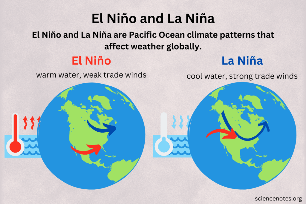
What is El Niño?
El Niño, meaning “the little boy” in Spanish (referring to the Christ child because it often appears around Christmas), is characterized by unusually warm ocean temperatures in the central and eastern tropical Pacific Ocean. This warming disrupts normal weather patterns and can lead to a variety of impacts around the globe. The warmer waters change atmospheric circulation, affecting rainfall, temperature, and storm patterns.
Causes of El Niño
El Niño events typically occur every two to seven years. They are triggered by a weakening or reversal of the easterly trade winds that normally blow across the Pacific Ocean. These winds usually push warm surface water towards Asia and Australia, allowing cooler, nutrient-rich water to upwell along the coast of South America. When the trade winds weaken, the warm water sloshes back eastward, suppressing the upwelling and leading to warmer sea surface temperatures in the eastern Pacific.
Global Impacts of El Niño
The impacts of El Niño are far-reaching and can vary depending on the intensity of the event. Some common effects include:
- Increased rainfall and flooding in South America: The warmer waters lead to increased evaporation and rainfall, often causing severe flooding in countries like Peru and Ecuador.
- Drought in Australia and Southeast Asia: The shift in atmospheric circulation can lead to drier conditions in these regions, impacting agriculture and water resources.
- Warmer temperatures globally: El Niño events often contribute to record-breaking global temperatures.
- Changes in hurricane activity: El Niño can suppress hurricane activity in the Atlantic Ocean but increase it in the eastern Pacific.
What is La Niña?
La Niña, meaning “the little girl” in Spanish, is the opposite phase of ENSO. It is characterized by unusually cold ocean temperatures in the central and eastern tropical Pacific Ocean. La Niña strengthens the normal trade winds, pushing more warm water towards Asia and Australia and enhancing the upwelling of cold water along the coast of South America.
Causes of La Niña
La Niña events also occur every few years, often following an El Niño event. They are caused by a strengthening of the easterly trade winds, which intensifies the normal patterns of warm water pooling in the western Pacific and cold water upwelling in the eastern Pacific.
Global Impacts of La Niña
Like El Niño, La Niña has significant global impacts, though often in the opposite direction. Some common effects include:
- Drought in the southwestern United States: La Niña can lead to drier conditions in this region, impacting water resources and agriculture.
- Increased rainfall in Australia and Southeast Asia: The intensified trade winds bring more moisture to these regions, leading to increased rainfall and potential flooding.
- Colder temperatures in some regions: La Niña can contribute to colder winters in parts of North America and Europe.
- Increased hurricane activity in the Atlantic Ocean: La Niña can weaken wind shear, creating more favorable conditions for hurricane formation in the Atlantic.
Key Differences Between El Niño and La Niña
The most fundamental difference between El Niño and La Niña lies in the sea surface temperatures in the central and eastern tropical Pacific Ocean. El Niño is characterized by warmer-than-average temperatures, while La Niña is characterized by colder-than-average temperatures. This temperature difference drives a cascade of atmospheric changes that lead to contrasting weather patterns around the world.
Temperature
The primary difference is the sea surface temperature anomaly. El Niño features positive anomalies (warmer than average), and La Niña features negative anomalies (colder than average). These anomalies are measured against a baseline average, typically over a 30-year period.
Trade Winds
Trade winds play a critical role. El Niño is associated with weakened or reversed trade winds, whereas La Niña is associated with strengthened trade winds. This difference in wind patterns directly affects the distribution of warm and cold water across the Pacific.
Rainfall Patterns
Rainfall patterns are drastically different. El Niño typically brings increased rainfall to South America and drought to Australia and Southeast Asia. La Niña, conversely, brings increased rainfall to Australia and Southeast Asia and drought to the southwestern United States.
Global Impacts
While both El Niño and La Niña have global impacts, the nature of those impacts differs. El Niño often contributes to warmer global temperatures, while La Niña can have a cooling effect in some regions. The difference in their influence on hurricane activity is also noteworthy.
Monitoring and Predicting El Niño and La Niña
Scientists use a variety of tools and techniques to monitor and predict El Niño and La Niña events. These include:
- Satellite observations: Satellites equipped with sensors can measure sea surface temperatures and wind patterns across the Pacific Ocean.
- Ocean buoys: A network of buoys, known as the Tropical Atmosphere Ocean (TAO) array, provides real-time data on ocean temperatures, currents, and winds.
- Climate models: Sophisticated computer models simulate the Earth’s climate system and can be used to predict the onset and intensity of El Niño and La Niña events.
These tools help scientists understand the complex interactions between the ocean and atmosphere that drive ENSO and improve the accuracy of forecasts. Understanding the difference between El Niño and La Niña allows for better prediction.
Why Understanding the Difference Matters
Understanding the difference between El Niño and La Niña is crucial for several reasons:
- Disaster preparedness: Accurate forecasts can help communities prepare for extreme weather events, such as floods, droughts, and heatwaves.
- Resource management: Understanding the potential impacts on agriculture, water resources, and energy production can help governments and businesses make informed decisions.
- Climate change research: Studying ENSO can provide insights into the complex dynamics of the Earth’s climate system and help improve our understanding of climate change.
The ability to anticipate and mitigate the impacts of El Niño and La Niña is essential for building resilient communities and protecting the environment. The difference between El Niño and La Niña is important to recognize for effective planning.
Conclusion
El Niño and La Niña are two powerful climate patterns that have significant global impacts. While they are opposite phases of the same phenomenon, the difference between El Niño and La Niña in their effects on weather patterns and regional climates is substantial. By understanding the causes, impacts, and monitoring techniques associated with these events, we can better prepare for and mitigate the risks they pose. Further research and improved forecasting models will continue to enhance our ability to predict and respond to these important climate phenomena. It’s vital to stay informed and understand this critical difference.
While a PDF might offer a convenient way to store information, this article provides a more dynamic and up-to-date understanding of the difference between El Niño and La Niña. [See also: The Impact of Climate Change on Global Weather Patterns] [See also: Understanding Ocean Currents and Their Role in Climate]
